


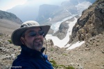
Trip Report: Jan. 17 - 19, 2009 (solo Texas hiker)
+3
ulhiker
ED
RedBuffalo
7 posters
Page 1 of 1

Trip Report: Jan. 17 - 19, 2009 (solo Texas hiker)
![]() by RedBuffalo Sat Jan 24, 2009 11:28 am
by RedBuffalo Sat Jan 24, 2009 11:28 am
Hope you guys don't mind me adding my version of the ERL trail. I enjoyed meeting up with you all on the trail. It was a great weekend for backpacking!
The details:
Trail Distance: 26.5 miles
Elevation Gain: approx. 800 ft climbs up six mountains
Water Crossings: multiple creek (rock hopping) crossings and at least 6 wet (take the boots off) crossings.
Pack Weight: 43 pounds
Day 1: I drove to Texarkana on Friday night and then left early Sat. and drove to Albert Pike RA. I was on the trail by 9:30 am heading in a clockwise direction w/ outside temps in the low 40s with plans to hike 9 miles each day, which I estimated would take approximately 5 hours w/ lunch and water crossings. The trails are well marked and wind up and down rock bluffs and around flowing creeks. I made my first wet river crossing at 3.5 miles. The water was painfully cold (but only for a few minutes) and ice sickles were hanging from the rocks. My next wet crossing came at 5 miles and it included a double crossing w/ a sandbar island in between. The first section went fine and as I approached the section stretch I cursed myself by taking a picture of the ice dangling from the rocks and thinking "This is the shot I took right before I fell in." My confidence was high from the earlier crossings so I subconsciously was moving faster to avoid spending too much time in the freezing water, another mistake was keeping my hands in the straps of my trekking poles, which restricted my hand movement during the fall. About half way across I slipped / fell right knee forward, I was falling and there was no recovering. I went in from the neck down and to the right and barely caught myself with my right hand and later my left. I managed to push myself up and regain my footing. First thoughts were to build a fire. I found a camp area along the bank and pulled out dry cloths, stripped down, and then noticed I had cut my right knee and scraped my forearm. Dry cloths, bandaged cuts, 800mg motrin, a little lunch, and I was back on the trail - not looking forward to the next wet crossing, which I knew was a few miles away. I passed some semi-fresh black bear dung on the trail so I'm doubly cautious at this point. Next river crossing I focused on the details. Time in the water was of no concern. I took my hands out of the trekking poles straps and used them much like a cane. Each step was calculated with poles planted (probably over kill, but at this point necessary) and the crossing was a piece of cake. I suppose being solo added to my level of caution - plus I had only seen one day hiker at this point. I watched my GPS and started looking for a camp site once I reached 9 miles and found one between two rock hopping creeks so that I could treat water for the following day. Hung my wet cloths (which I had in my collapsable bucket dangling from the backpack), set up the tent, got a bucket of water and put in the tablets, built a fire ring from nearby rocks, and gathered firewood. A hiker came by who was meeting three friends at the Eagle Rock lookout a few miles up the trail. He warned me of the upcoming six mountain climb. He was hiking from the opposite direction of his group to avoid the climbs and was going to join them coming back the way he had came. He said they hiked the loop a few years earlier and that stretch of mountains was the worse trail he had ever been on. i think his words were "There's a lot of nice trails in Arkansas and that isn't one of them." The fire was nice and I attempted to dry my cloths - it was interesting to see the steam pouring out of my ut sweatshirt (btw - wet cotton does not dry in cold weather). I bedded down to what turned out to be 11 hours of peaceful sleep.

Day 2: I woke up to freezing temps w/ my thermometer reading 22.5 degrees. Don't know if that was accurate, but I do know there was frost on my sleeping bag, tent, pack, and my water bottle and camelback tube were frozen. One hot cut of coffee and a granola bar later and camp was broken down and I was back on the trail by 9:10 am. There were more rock hopping crossings, which I approached with caution, but later moved across pretty quickly (you get used to it, because there are many). The Arkansas group joined with the hiker from the day before stopped and visited for a few minutes (they were going ccw). They warned me again of the uphill pulls that were ahead of me. It wasn't long before I got a taste of what they had been talking about. Although not terribly long in distance, the climbs were, for the most part, absent of switchbacks, which justifies the difficulty. It reminded me of Asinine Hill on the North Kaibab Trail and long stretches of trail hiking Mt. Elbert in Colorado. I typically get in a slow marching type zone when faced with these "pulls" mentally counting a cadence and taking longer strides. Up and down the first one I met three guys from Mississippi - one doctoring blisters with mole skin. Anyone hiking with me knows that I'm too friendly with mole skin. I'm elated to report that my new Keen hiking boots (larger toe box design) have all but solved that problem. Absolutely no blisters for the first two days of backpacking and only two hot spots on the third day. I'm ordering another pair of the same model soon. I passed two men while hiking up the third or fourth mountain (I wasn't counting) and once I reached 18 miles on the GPS I began looking for a place to camp. I noticed on my map that Straight Creek was one of the last water sources before climbing the last mountain so that was the logical place to camp, which I arrived at 2:45 pm. I found a nice fire ring with some left over firewood from earlier campers. Did the camp routine; tent, treated water for the next day, gathered firewood, and hung the still wet sweatshirt. Also, most of my gear was slightly damp from having frost on it that morning and I was thinking I would just have to dry it out later. The Mississippi boys passed by about 5 pm with intentions of getting over the last mountain before dark. A couple from Louisiana stopped by and asked how far it was to Albert Pike. Going primarily by my GPS odometer I told them approx. 9 miles (figuring that I had already traveled over 18 miles) and I let them have a look at my map. This calculation proved to be inaccurate. Another nice campfire and lasagna w/ meat sauce, plus some catching up on my magazine reading (PhotoShop User, Backpacker, and PC Photography) and I was ready to log in 10 hours of solid sleep.

Day 3: AM temps were 38 degrees at camp and I later recorded 33 at the top the next mountain. The good news was there was no frost at camp and all my gear was now dry. Looking at the map somehow the distance wasn't adding up, but I still wanted to trust my GPS odometer - thinking I was 9 miles from the Albert Pike trailhead. Given the uncertainty, I decided to forgo my coffee and hit the trail early. I left camp at 7:25 am and made the last major "pull" of the trail. I met the Mississippi group at the Little Missouri River trailhead, which I now know is over 10 miles from Albert Pike. I stepped up my pace, but still enjoyed the beautiful scenery along the Little Missouri River. The trail winds along a mountain side and follows the river with several crossings. An hour or so later I arrived at the Little Mo Waterfall picnic area and met the group from Arkansas. They confirmed my concerns of the longer distance to Albert Pike. Nice bunch of guys - even though they gave me the "down longhorn" hand gesture (my ut sweatshirt was dry). We discussed the trail and the other groups we had met. Both the LA couple and Mississippi bunch had 3+ mile further to go than I did so i knew it would be a long day for all of us. They connected me with ArkansasBackcountry.com where I later read their trip report and found out the LA couple got lost and ended up hiking down a forest road where they rescued them and transported them back to their car. I pretty much humped it the last 3 miles and even gave up on taking my boots off on the last major wet crossing. I just sloshed through the river and went about my business. I reached the trailhead at 1:30 pm and gave out a Texas Battle Cry.
Summary: Challenging. I rate it right up there with the Grand Canyon rim-to-rim (four day 26 miles w/ park water sources and established campsites). Mainly because of being solo, which brought on its own challenges, but also because of the distance per day, treating water, river crossings, and being in a National Forest and not a National Park. Would I do it again - sure! I'd like to do it in four days during the Fall and enjoy the scenery more and maybe bring in my camera gear. June tells me no more solo hikes, but, of course, I'm already looking for another adventure...
The details:
Trail Distance: 26.5 miles
Elevation Gain: approx. 800 ft climbs up six mountains
Water Crossings: multiple creek (rock hopping) crossings and at least 6 wet (take the boots off) crossings.
Pack Weight: 43 pounds
Day 1: I drove to Texarkana on Friday night and then left early Sat. and drove to Albert Pike RA. I was on the trail by 9:30 am heading in a clockwise direction w/ outside temps in the low 40s with plans to hike 9 miles each day, which I estimated would take approximately 5 hours w/ lunch and water crossings. The trails are well marked and wind up and down rock bluffs and around flowing creeks. I made my first wet river crossing at 3.5 miles. The water was painfully cold (but only for a few minutes) and ice sickles were hanging from the rocks. My next wet crossing came at 5 miles and it included a double crossing w/ a sandbar island in between. The first section went fine and as I approached the section stretch I cursed myself by taking a picture of the ice dangling from the rocks and thinking "This is the shot I took right before I fell in." My confidence was high from the earlier crossings so I subconsciously was moving faster to avoid spending too much time in the freezing water, another mistake was keeping my hands in the straps of my trekking poles, which restricted my hand movement during the fall. About half way across I slipped / fell right knee forward, I was falling and there was no recovering. I went in from the neck down and to the right and barely caught myself with my right hand and later my left. I managed to push myself up and regain my footing. First thoughts were to build a fire. I found a camp area along the bank and pulled out dry cloths, stripped down, and then noticed I had cut my right knee and scraped my forearm. Dry cloths, bandaged cuts, 800mg motrin, a little lunch, and I was back on the trail - not looking forward to the next wet crossing, which I knew was a few miles away. I passed some semi-fresh black bear dung on the trail so I'm doubly cautious at this point. Next river crossing I focused on the details. Time in the water was of no concern. I took my hands out of the trekking poles straps and used them much like a cane. Each step was calculated with poles planted (probably over kill, but at this point necessary) and the crossing was a piece of cake. I suppose being solo added to my level of caution - plus I had only seen one day hiker at this point. I watched my GPS and started looking for a camp site once I reached 9 miles and found one between two rock hopping creeks so that I could treat water for the following day. Hung my wet cloths (which I had in my collapsable bucket dangling from the backpack), set up the tent, got a bucket of water and put in the tablets, built a fire ring from nearby rocks, and gathered firewood. A hiker came by who was meeting three friends at the Eagle Rock lookout a few miles up the trail. He warned me of the upcoming six mountain climb. He was hiking from the opposite direction of his group to avoid the climbs and was going to join them coming back the way he had came. He said they hiked the loop a few years earlier and that stretch of mountains was the worse trail he had ever been on. i think his words were "There's a lot of nice trails in Arkansas and that isn't one of them." The fire was nice and I attempted to dry my cloths - it was interesting to see the steam pouring out of my ut sweatshirt (btw - wet cotton does not dry in cold weather). I bedded down to what turned out to be 11 hours of peaceful sleep.
Day 2: I woke up to freezing temps w/ my thermometer reading 22.5 degrees. Don't know if that was accurate, but I do know there was frost on my sleeping bag, tent, pack, and my water bottle and camelback tube were frozen. One hot cut of coffee and a granola bar later and camp was broken down and I was back on the trail by 9:10 am. There were more rock hopping crossings, which I approached with caution, but later moved across pretty quickly (you get used to it, because there are many). The Arkansas group joined with the hiker from the day before stopped and visited for a few minutes (they were going ccw). They warned me again of the uphill pulls that were ahead of me. It wasn't long before I got a taste of what they had been talking about. Although not terribly long in distance, the climbs were, for the most part, absent of switchbacks, which justifies the difficulty. It reminded me of Asinine Hill on the North Kaibab Trail and long stretches of trail hiking Mt. Elbert in Colorado. I typically get in a slow marching type zone when faced with these "pulls" mentally counting a cadence and taking longer strides. Up and down the first one I met three guys from Mississippi - one doctoring blisters with mole skin. Anyone hiking with me knows that I'm too friendly with mole skin. I'm elated to report that my new Keen hiking boots (larger toe box design) have all but solved that problem. Absolutely no blisters for the first two days of backpacking and only two hot spots on the third day. I'm ordering another pair of the same model soon. I passed two men while hiking up the third or fourth mountain (I wasn't counting) and once I reached 18 miles on the GPS I began looking for a place to camp. I noticed on my map that Straight Creek was one of the last water sources before climbing the last mountain so that was the logical place to camp, which I arrived at 2:45 pm. I found a nice fire ring with some left over firewood from earlier campers. Did the camp routine; tent, treated water for the next day, gathered firewood, and hung the still wet sweatshirt. Also, most of my gear was slightly damp from having frost on it that morning and I was thinking I would just have to dry it out later. The Mississippi boys passed by about 5 pm with intentions of getting over the last mountain before dark. A couple from Louisiana stopped by and asked how far it was to Albert Pike. Going primarily by my GPS odometer I told them approx. 9 miles (figuring that I had already traveled over 18 miles) and I let them have a look at my map. This calculation proved to be inaccurate. Another nice campfire and lasagna w/ meat sauce, plus some catching up on my magazine reading (PhotoShop User, Backpacker, and PC Photography) and I was ready to log in 10 hours of solid sleep.
Day 3: AM temps were 38 degrees at camp and I later recorded 33 at the top the next mountain. The good news was there was no frost at camp and all my gear was now dry. Looking at the map somehow the distance wasn't adding up, but I still wanted to trust my GPS odometer - thinking I was 9 miles from the Albert Pike trailhead. Given the uncertainty, I decided to forgo my coffee and hit the trail early. I left camp at 7:25 am and made the last major "pull" of the trail. I met the Mississippi group at the Little Missouri River trailhead, which I now know is over 10 miles from Albert Pike. I stepped up my pace, but still enjoyed the beautiful scenery along the Little Missouri River. The trail winds along a mountain side and follows the river with several crossings. An hour or so later I arrived at the Little Mo Waterfall picnic area and met the group from Arkansas. They confirmed my concerns of the longer distance to Albert Pike. Nice bunch of guys - even though they gave me the "down longhorn" hand gesture (my ut sweatshirt was dry). We discussed the trail and the other groups we had met. Both the LA couple and Mississippi bunch had 3+ mile further to go than I did so i knew it would be a long day for all of us. They connected me with ArkansasBackcountry.com where I later read their trip report and found out the LA couple got lost and ended up hiking down a forest road where they rescued them and transported them back to their car. I pretty much humped it the last 3 miles and even gave up on taking my boots off on the last major wet crossing. I just sloshed through the river and went about my business. I reached the trailhead at 1:30 pm and gave out a Texas Battle Cry.
Summary: Challenging. I rate it right up there with the Grand Canyon rim-to-rim (four day 26 miles w/ park water sources and established campsites). Mainly because of being solo, which brought on its own challenges, but also because of the distance per day, treating water, river crossings, and being in a National Forest and not a National Park. Would I do it again - sure! I'd like to do it in four days during the Fall and enjoy the scenery more and maybe bring in my camera gear. June tells me no more solo hikes, but, of course, I'm already looking for another adventure...
Last edited by RedBuffalo on Sun Jan 25, 2009 10:16 pm; edited 1 time in total (Reason for editing : adding photos)
RedBuffalo- Backcountry Explorer
- Posts : 132
Join date : 2009-01-22
Age : 60
Location : East Texas -

Re: Trip Report: Jan. 17 - 19, 2009 (solo Texas hiker)
![]() by ED Sat Jan 24, 2009 12:41 pm
by ED Sat Jan 24, 2009 12:41 pm
I live in Texarkana so the next time you wanna go, if you want company let me know . ERL is at the top of my to do list.
What part of Texas are you from?
What part of Texas are you from?

ED- Trail Guide
- Posts : 264
Join date : 2009-01-06
Age : 55
Location : Texarkana,Texas
Re: Trip Report: Jan. 17 - 19, 2009 (solo Texas hiker)
![]() by ulhiker Sat Jan 24, 2009 12:50 pm
by ulhiker Sat Jan 24, 2009 12:50 pm
RedBuffalo:
Fantastic report. I was surprised to hear how cold it got on the second day down where you camped the first night. We camped up on top of Eagle Rock Vista and, according to my thermometer, it only got down to around 42 deg. We had wind most of the night, so that, plus the elevation, may be the reasons for the big difference.
The second night, we camped right on the river and it got down to near 32 deg.
BTW, you saw the trail at its best as far as scenery goes. Once we get leaf-on, the vistas and views tend to disappear and the trail tends to become a tunnel.
Lew hiked this trail back in May and he can tell you more about how clostrophobic it becomes. Still a nice trail, just lose some of the views that you experienced on this hike.
Again, it was great meeting you on this hike and hope to see you on another one.
UL

ulhiker- Mountain Man
- Posts : 672
Join date : 2008-04-17
Age : 65
Location : Conway, Arkansas
Re: Trip Report: Jan. 17 - 19, 2009 (solo Texas hiker)
![]() by lew1043 Sat Jan 24, 2009 2:37 pm
by lew1043 Sat Jan 24, 2009 2:37 pm
Red Buffalo
Great Trip report! We enjoyed meeting you also even if you had a Texas sweatshirt on. Maybe you can come up and hike with us sometime.
Lew
Great Trip report! We enjoyed meeting you also even if you had a Texas sweatshirt on. Maybe you can come up and hike with us sometime.
Lew
lew1043- Trail Guide
- Posts : 214
Join date : 2008-04-17
Age : 50
Location : Greenbrier, AR
Re: Trip Report: Jan. 17 - 19, 2009 (solo Texas hiker)
![]() by Jay Sat Jan 24, 2009 3:55 pm
by Jay Sat Jan 24, 2009 3:55 pm
Thanks for sharing a great trip report Red Buffalo!
And welcome to the site!
And welcome to the site!

Jay- Admin

- Posts : 583
Join date : 2008-03-13
Location : Arkansas -
Re: Trip Report: Jan. 17 - 19, 2009 (solo Texas hiker)
![]() by ouachita hiker Sat Jan 24, 2009 11:22 pm
by ouachita hiker Sat Jan 24, 2009 11:22 pm
Enjoyed your report. I want to get on that trail soon.. Reports like you guys sure stokes the fire!!
OH
OH

ouachita hiker- Master of the Arkansas Backcountry
- Posts : 1285
Join date : 2008-04-03
Re: Trip Report: Jan. 17 - 19, 2009 (solo Texas hiker)
![]() by Preacha Man Sat Jan 24, 2009 11:33 pm
by Preacha Man Sat Jan 24, 2009 11:33 pm
I so want to hike this trail now. Maybe I can do it this spring on a Thursday-Saturday thing. I need to get my miles up so that the trail stompers can win. Great detail in your report, and I am glad that you were able to change into dry clothes so soon. I NEVER take cotton with me for that very reason, all my clothes from head to toe are snynthetic.

Preacha Man- Mountain Man
- Posts : 831
Join date : 2008-06-24
Age : 45
Location : Northwest Arkansas -
Re: Trip Report: Jan. 17 - 19, 2009 (solo Texas hiker)
![]() by RedBuffalo Mon Jan 26, 2009 7:22 am
by RedBuffalo Mon Jan 26, 2009 7:22 am
I typically avoid cotton as well. I had three layers of poly, but brought a fleece, flannel, and sweatshirt for the cold. Luckily I had shed and strapped the flannel and fleece on the back of my pack before the plunge. One thing about backpacking - every trip you go on makes you a better backpacker.
RedBuffalo- Backcountry Explorer
- Posts : 132
Join date : 2009-01-22
Age : 60
Location : East Texas -
Re: Trip Report: Jan. 17 - 19, 2009 (solo Texas hiker)
![]() by Preacha Man Mon Jan 26, 2009 3:46 pm
by Preacha Man Mon Jan 26, 2009 3:46 pm
RedBuffalo wrote:One thing about backpacking - every trip you go on makes you a better backpacker.
Well said! If you do not learn then you will be miserable. That is how I shaved a lot of weight off of my pack. I learned a lot that I was carrying wasn't needed, and I never used it. Everytime I came home, I would go thru my pack and if I didn't use it, I got rid of it (Except for my first aide kit of course). Eventualy I learned that I didn't need 3 pair of underwear for a 3 day trip, heck, who am I trying to impress. The only clothes I carry now are socks, and the clothes that I shed.
Preacha Man- Mountain Man
- Posts : 831
Join date : 2008-06-24
Age : 45
Location : Northwest Arkansas -
Eagle Rock Loop Patch
![]() by RedBuffalo Sun Feb 01, 2009 3:28 pm
by RedBuffalo Sun Feb 01, 2009 3:28 pm
I figured this was common knowledge, but wanted to post it just in case someone wasn't aware of it. Once you complete the trail you can request a free patch from the Glenwood NFS office (while supplies last they told me).
Anyway, here is what it looks like and I'm pretty proud to have one.

Anyway, here is what it looks like and I'm pretty proud to have one.
Last edited by RedBuffalo on Sun Feb 01, 2009 3:34 pm; edited 1 time in total (Reason for editing : adding image)
RedBuffalo- Backcountry Explorer
- Posts : 132
Join date : 2009-01-22
Age : 60
Location : East Texas -
» Buffalo Solo Trip Report
» Preacha's Buffalo Solo Trip Report
» ERL Trip Report from The First Annual Tri State Solo Group Hike
» January 17-19 2009 Eagle Rock Loop Trip Report!
» Former UFC champion Evan Tanner's body recovered after solo hiking trip
» Preacha's Buffalo Solo Trip Report
» ERL Trip Report from The First Annual Tri State Solo Group Hike
» January 17-19 2009 Eagle Rock Loop Trip Report!
» Former UFC champion Evan Tanner's body recovered after solo hiking trip
Page 1 of 1
Permissions in this forum:
You cannot reply to topics in this forum
» Wilderness First Aid classes
» Waterfalls Review
» Hiker's Hell!
» downloading iphone photos
» Summertime....
» LINCOLN LAKE
» My Neighbor Boy's Birthday Butterfield Hike!!